|
|
|||||||||
|
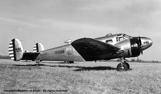
Beech 18 AT-7 Navigator Copyright Museum of Flight - all rights reserved September, 2008 |
|||||||||
|
FINAL FLIGHT a blog by Peter Stekel FINAL FLIGHT is the story of four aviators lost in Sequoia & Kings Canyon National Parks on November 18, 1942 |
|||||||||
|
FINAL FLIGHT, coming from Wilderness Press in 2010 |
|||||||||
|
Read more about FINAL FLIGHT here. |
|||||||||
|
|
|||||||||
| September 19 | |||||||||
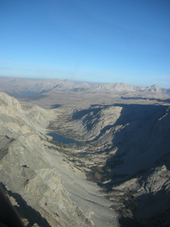
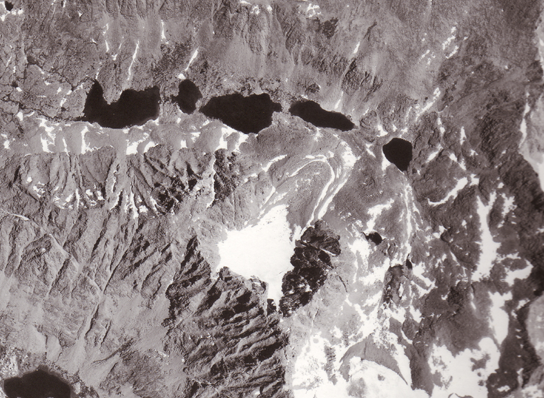
| Flew over the crash site this morning on a private trip with Steve Ivey from the Eastern Sierra Regional Airport in Bishop. We had to leave around sunrise to avoid turbulence. What an awesome ride! Scary too. Once you get up into the air the Sierra appears to be an endless series of sharp peaks and ridges. During the 19th century, the Sierra was considered an impenetrable barrier - a wall - to travel. I've never seen it that way until now. It would be frightening to be confronted with these mountains during a storm while trying to find a passage over them in an airplane being rocked and buffeted by high winds. |
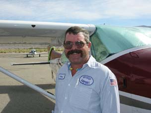 Steve Ivey |
||||||||
|
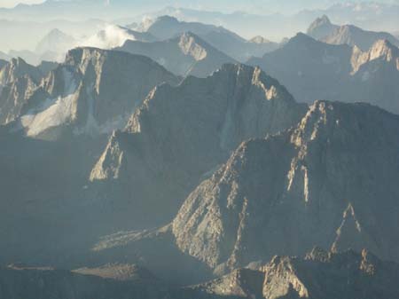
The very first thing I noticed was [given my familiarity with the area and given the topo map on my lap] how quickly I became disoriented. I knew the cardinal points of the compass and could see the Owens Valley, White Mountains, and Sierra Nevada, but it wasn't until we were almost over Mt. Darwin that I knew were I was! We flew over Lamarck Col and Mendel Glacier - keeping a safe buffer of airspace to ensure we didn't add ourselves to the long list of airplane wrecks in the Sierra. Even so, it made me wonder why Gamber would have tried to cross the mountains here at Lamarck Col [12880'] when 1/4 mile north is Piute Pass [11423']. From the air, Piute Pass to the west looks like a low, broad trough leading into the Central Valley via a plateau and wide, deep valleys. |
|||||||||
|
Mt. Darwin and Mt Mendel from the air
Mt. Mendel and Mendel Glacier from the air
|
|||||||||
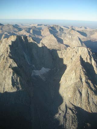
| Referring to my aeronautical sectional map for this part of the country, Piute Pass is clearly marked and no high obstacles are seen. Could Lt. Gamber and his navigation students have been trying to find Piute Pass and missed it? Perhaps. The sectional maps are awfully small scale and it would not be difficult to confused on low spot on a ridge with another, especially when being jostled about by turbulence, being confused in an unfamiliar area, and having clouds obscure important landmarks. | |||||||||
|
Piute Pass from the air [looking west.... and looking good] |
|||||||||
|
That afternoon I visited the headquarters for the Inyo National Forest in Bishop, looking for aerial photos of Mendel Glacier. Mike Hilton, the forest archeologist and Acting Heritage Program Manager, was very helpful and I found some photos from 1947. Look HERE to see one. More photos from 1947, plus photos from 1948, 1962, 1972, and 1983 will be posted in the October blog. John Louth, chief of interpretation for the White Mountain district of the Inyo National Forest was instrumental in helping me locate these other aerial photos. As for finding any paper records about the two operations or info on forest ranger Neil Perkins [who accompanied the 1947 military exploratory recovery operation guided by Bill Bond], Mike sent out an email to his cohorts in hopes they might have some leads. Stay tuned. Then I moved on to the Bishop Police Station. In October, 2005, Michael Nozel and Mark Postle made their initial report about discovering a body on Mendel Glacier at the Bishop PD. I wanted to read this officer's report [none was made since the official report was filed by Inyo County deputy sheriff Paul Baldwin] and interview him about his impressions. Unfortunately since there is no record of the encounter, I was unable to do this. However, the desk officer was kind enough to mention that turnover in the police force has been slight since 2005 and that I could leave a note for the "briefing notebook." Therefore, a chance exists that the officer will get in touch with me. |
|||||||||
| September 18 | |||||||||
| Took Michele to Reno today and then met with
Dr. Laura Edwards and Dr. John Lewis with the
Western Region Climate Center,
Desert Research Institute. We reviewed the weather from November 18, 1942.
Dr. Lewis is an expert on severe weather and was mightily impressed by the
storm of that day. It was able to travel to southern California from
southern Puget Sound -about 800 or more miles - in 24 hours. That storm
was cooking!!! We discussed and reviewed many possible scenarios for what caused the crash, why Lt. Gamber was where he was, and how he might have gotten there. One thing I feel for certain, between 8:30 AM and 1:30 PM [the assumed flight time of the Beech 18 AT-7 flown by Lt. William Gamber] on November 18, 1942 the storm could not have been much further south than Lake Tahoe though there was much turbulence to the south preceding the storm. Perhaps there were various strata of clouds obscuring the Sierra summits. Maybe conventional build up of clouds too. All this has important ramifications for explaining what Gamber and crew were doing so far south and east of their supposed route. |
|||||||||
| September 17 | |||||||||
| Hiking out of the Piute Creek area we met Fred Baumann and Lou Tichacek. They have been hiking together for over 50 years and visited Darwin Canyon over Lamarck Col in either 1956 or 1957. They had some great stories to tell about their travels. In the 1970s, Fred was hiking in Yosemite and fell upon the body of a kayaker who was killed while boating on the Tuolumne River. When I get home to Seattle I plan to talk some more with them and hopefully get some photos that Fred took of the glacier during their trip. | |||||||||
| September 7-9 | |||||||||
| On the 7th, Michele and I met up with Mark
Grossi and Mark Crosse from the Fresno Bee and together hiked up to the
tarn below the eastern face of Lamarck Col. The day was hot but the night
was cold. Smoke from a fire on the west side in Tehipite Valley obscured
the White Mountains, east of us and on the eastern side of Owens Valley. Monday, the 8th, we climbed to the top of the Col and dropped down to Darwin Canyon. While Mark and Mark stayed behind, Michele and I hiked up to the glacier. The landscape has changed dramatically from last year - the glacier is very much smaller. In some places it looks as if it has subsided as much as six feet. Recall that Mendel is a "rock" glacier and that the rocks insulate the ice, causing the glacier to melt in place rather than retreat uphill as would a "clean" glacier. We found the tire and engines we discovered last year. Much of the ice that enclosed this wreckage from 2007 is gone. Then, up to the site when Glenn Munn's body was found. We had a hard time locating the spot, even with my GPS, until Michele noticed that all the rocks in the area had moved. Had this been the first time we visited the glacier, Munn would have remained hidden as a large rock that had previously stood above him has fallen over. This rock would have covered Munn. so, yet another serendipitous event. We were lucky to find Glenn Munn last year - we certainly would not have found him this year.
|
|||||||||
| Mark and Mark returned to the glacier with us on the 9th. While they explored the lower regions, Michele and I climbed easily to the top of the eastern side of the Mendel bergschrund. We didn't find anything. Then, we descended to the north side of the glacier and along with the Marks discovered various pieces of the wings, including a large piece of metal with the fuel door. There were pieces of laminate wood - probably from desks the student navigators used. I found seat covers and stuffing from the cockpit seats, some olive drab material, and lots of pieces of shredded aluminum. This wreckage was not visible last year as the glacier was much larger in 2007. Will the glacier ever allow it's mystery to be solved, it's secrets to be revealed? Only more melting will allow this to occur. | |||||||||
| On the 9th, the Marks left and returned over the Col. The morning was cold and by 10 AM it had begun to snow. Michele and I met backcountry ranger, Dave Gordon, at Darwin Canyon Lake #1 and had a pleasant 2.5 hour chat about the backcountry, wilderness management, and airplane wrecks. Dave had been dispatched by park HQ to come up to the glacier to observe our investigations but had not seen anyone at Lake #4 and assumed we were either not there or not coming. He didn't realize we were camped at Lake #5. We hope to meet up again in a few weeks when I return to Mendel Glacier with Glenn Munn's nephews. | |||||||||
| I asked Dave if he felt stock animals ever made it past Lake #1. I've been wondering how Capt. Sulzbacher got all his heavy gear up to the glacier in 1948. There are some significant outcrops of granite at the lake's lower end that make hiking a chore and it seems impervious to stock travel. Dave thinks this was the lower limit of stock access. "But I've been wrong about where people take stock before!" he exclaimed. | |||||||||
| BTW - there are fish in the lower three Darwin Canyon lakes. | |||||||||
| Michele and I hiked on for the rest of the week, proceeding up Evolution Valley, using a knapsack pass to enter Davis Lake basin and then crosscountry travel down N. Fk. Goddard Creek to the Goddard Creek trail, thence down to Piute Creek and up over Piute Pass. A great 11 days backpacking trip. | |||||||||
| September 1 | |||||||||
|
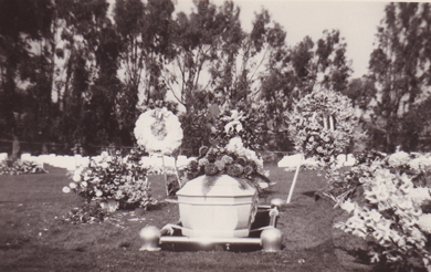
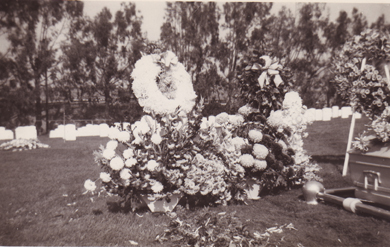
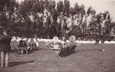
Photos of 1948 group burial of Beech 18 AT-7 crew in Golden Gate National Cemetery in San Bruno, CA [courtesy of Glenn Munn family].
|
|||||||||
|
|||||||||
|
write to: peter[at]FinalFlightTheBook.com |
|||||||||
|
copyright 2010 Peter Stekel all rights reserved |
|||||||||
|
FINAL FLIGHT, coming from Wilderness Press in 2010 |
|||||||||
